The 1947 Partition: Drawing the Indo-Pakistan Boundary
by Lucy Chester
The author, a visiting fellow at the Center for International Security and Cooperation at Stanford University, is a doctoral candidate in history at Yale University. Drawing from her dissertation, she considers here the background to timely questions associated with the Kashmir dispute. She raises the policy question of partition as a tool for crisis management or resolution, and she provides useful historical evidence for scholars wishing to draw contemporary lessons.—Ed.
Introduction
The 1947 partition of South Asia has had lasting repercussions not only for the region, but also for the larger international community. Border tensions between India and Pakistan have taken on a new magnitude since both countries carried out nuclear tests in May 1998. Surprisingly, historians have paid little attention to the creation of the Indo-Pakistani boundary, a key element of the 1947 division.1 This article analyzes the problematic procedure and format of the body responsible for delineating that boundary through the province of Punjab, the Radcliffe Boundary Commission.2 It is part of a larger project that will examine links between the boundary-making process and the repercussions of partition, particularly mass violence. The commission takes its name from its chairman, Sir Cyril Radcliffe. In the end, his boundary-making effort was a failure in terms of boundary-making, but a striking success in terms of providing political cover to all sides. The British seized the opportunity to withdraw from their onerous Indian responsibilities as quickly as possible; the Indian National Congress, the avowedly secular but primarily Hindu party headed by Jawaharlal Nehru and Sardar Patel, took control of India, as it had desired for so long. The Muslim League, which claimed to represent South Asia’s Muslims and was led by Muhammad Ali Jinnah, won Pakistan, the sovereign Muslim state for which it had campaigned.
Jinnah, Patel, and Nehru
Although the British had, in 1946, considered leaving India piecemeal, transferring power to individual provences as they withdrew, they concluded that such an approach was impractical. without defining the entity or entities that would come into power, they concluded that such an approach was impractical. It would not be possible to hand over power without making it clear what international entity would take on that power; in order to define a new international entity, a new boundary was necessary. From a certain perspective, however, a rigorously and properly delineated boundary was not necessary to accomplish these political ends—any boundary line would do. Due to this fact and to a myriad of political pressures, the Radcliffe Commission failed to draw a geopolitically sound line delineated and demarcated in accordance with accepted international procedure. The Punjab's population distribution was such that there was no line that could neatly divide Hindus, Muslims, and Sikhs. Radcliffe's line was far from perfect, but it is important to note that alternative borders would not necessarily have provided a significant improvement. There is, in contrast, a great deal to be said about flaws in the boundary-making procedure—and why those flaws existed.
Significance
This territorial division is significant on multiple levels. As an episode in imperial history, it marked the beginning of a global trend towards decolonization. For South Asian history, it meant independence for India and Pakistan. Unfortunately, it also inaugurated Indo-Pakistani tension. Conflict between Hindus and Muslims had existed on the subcontinent, to a greater or lesser degree, for many centuries, but the partition brought that conflict to the international level—and exacerbated it. The results include three wars, in 1948, 1965, and 1971, as well as the Kargil conflict of 1999. The problem of Indo-Pakistani tension took on greater urgency when both India and Pakistan tested their nuclear weapons in May 1998, and current events in South Asia demonstrate the need for continued attention to and greater understanding of this vital region.
How did this division intensify the very conflict it was intended to resolve? Part of the answer lies in the drawing of the boundary. My primary goal is to clarify and analyze the boundary-making process, but having identified specific flaws in this division, I hope to lay them out in terms that might be useful for decision-makers considering partition as a tool to resolve conflict in other regions of the world.
Methodology
Because this project focuses on a controversial episode, which reasonable historians describe differently according to their own national or political biases, my first research priority was balancing these varied perspectives. Accordingly, I gathered archival material and conducted interviews in England, Pakistan, and India. In all three countries, I focused on government documents, examining material relating to the work of the Radcliffe Commission and to the repercussions of the Radcliffe Line. I also examined private papers, mostly of British officials serving the raj, but also, where accessible, the papers of Indian and Pakistani leaders. Regrettably, Radcliffe destroyed all his papers before he left India—in keeping, his biographer claims, with a lifelong habit of discarding material he no longer needed.3 As a result, it may be impossible ever to clarify Radcliffe’s thinking completely. I have attempted to compensate through archival research and through interviews with Radcliffe’s stepson and executor, with his private secretary on the Boundary Commission, and with the last surviving Pakistani official associated with the Punjab Boundary Commission.4
This research explores the balance between structural influences and the role of individuals. My story centers on a small number of individuals: Radcliffe, the man who had responsibility for the boundary line; Mountbatten, the last viceroy of India; Nehru and Patel, leaders of the Indian National Congress; and Jinnah, head of the Muslim League. But my argument also has a great deal to do with the sweeping drives of British imperialism, Indian and Pakistani nationalism, and decolonization. My conclusions about the forces that shaped the Indo-Pakistani boundary would seem to support a structural approach, but the lessons of this particular division could be read another way. If at any point enough individuals had decided to take another path—for example, if Radcliffe had withdrawn his services once he reached India and was informed of the August 15 deadline—the outcome could have been dramatically different. Alternatively, if the key individuals had had different backgrounds—for example, if all the Indian leaders had not been lawyers, but rather businessmen or engineers—the outcome could again have been very different. The story of the Radcliffe Commission concerns individuals attempting to do what they saw as best, and as a result both bowing to and struggling against the pressures of larger structural forces.
Historical Context
The 1947 partition was shaped not only by decades of Indian nationalist pressure on the British Government and by the rise of civil unrest in the subcontinent after World War Two, but also by Britain’s precarious economic position in the aftermath of the war. After nearly two centuries as an economic asset, British India had become a liability at a time when Britain could least afford it. In addition, American pressure to decolonize the subcontinent influenced both international and British domestic opinion against the raj. British India became a political and symbolic liability as well as an economic problem. These factors, combined with domestic political considerations for the newly elected Labour Party, meant that ridding itself of its responsibilities in India suddenly became a priority to His Majesty’s Government (HMG).
However, Indian independence had not always been such an urgent goal for the British Government. The first half of the twentieth century saw a series of small steps towards self-government in South Asia. Traditional imperialist historiography holds that these ventures marked carefully incremented progress, part of the process of training Indians to govern themselves. Other interpretations, including but not confined to South Asian nationalist schools, argue that these steps were actually sops intended to keep nationalists satisfied enough to prevent a more serious threat to British rule.5 This view holds that HMG had no intention of letting go its "jewel in the crown"—until it had no choice.
Many historians, imperialist and nationalist alike, trace the roots of partition to the Morley-Minto reforms of 1909. These changes increased Indian participation in their own governance, anticipating an eventual move to self-rule.6 By creating separate electorates for different religious groups, however, these reforms also "embed[ded] deeply in Indian life the idea that its society consisted of groups set apart from each other. . . . The result was the flowering of a new communal rhetoric, and ultimately, of the Pakistan movement."7 Politicians found religious rhetoric useful for rallying support, with dangerous results. The elections of 1937 and 1945-46, in which both Congress and the Muslim League rhetoric played on communal themes, provided further evidence of a lack of political cooperation at the highest levels.
With the onset of the Second World War, the Government of India found itself in a difficult position. HMG declared war on India’s behalf, without even a pretense of consulting Indian leaders. Indian politicians and public opinion were outraged. The prospect of civil unrest loomed.8 In 1942, with the Allies in urgent need of a reliable Indian base, Churchill dispatched Sir Stafford Cripps to India at the head of a Cabinet delegation charged with exploring the possibility of self-government after the war. Cripps offered an implicit promise that if India fought in World War II it would be granted freedom; Congress rejected this offer with Gandhi’s memorable phrase that it was a "post-dated cheque on a bank that was failing."9 In the aftermath of Cripps’s failed mission, Gandhi launched the "Quit India" movement, which the British repressed violently. Most Indians subsided into more or less supportive attitudes.10
With the end of the war, Indian leaders and people alike expected to be repaid, with independence, for their wartime backing. In Britain, the Conservatives were voted out and the Labour Party took power, under Clement Attlee. Meanwhile, the India Office was losing patience with its viceroy, Lord Wavell. Relations between the India Office and Wavell had been steadily worsening throughout 1946. Wavell, a career military man whose stolid exterior concealed a bent for writing poetry, had been viceroy of India since 1943. Left with the difficult job of guiding India through treacherous post-war waters, he sent increasingly blunt warnings to London that their Indian policies were misguided and inadequate to the challenges ahead. Lord Pethick-Lawrence, Britain’s Secretary of State for India, resented these warnings and paid less attention to them as time went on. In particular, Wavell’s outline of potential partition boundaries, the first serious discussion of the issue, received little attention. However, Wavell’s "Breakdown Plan," calling for a withdrawal of all British presence in South Asia, alarmed HMG. Attlee sent another cabinet mission to India in hopes of negotiating a less drastic outcome.11 The resulting proposal, known as the "ABC Plan," called for a loose federation to consist of three groups of provinces, each of which had the option to "opt out" of the federation. This proposal met a curious reception. It was first accepted, then rejected, by Congress; the Muslim League initially announced that it would cooperate, but in the aftermath of the Congress decision it renounced constitutional methods and declared "Direct Action" Day on August 16, 1946. "Direct Action Day" became the "Great Calcutta Killing," and the next thirteen months saw rioting and violence across North India.12
By the beginning of 1947, Pethick-Lawrence and Attlee had lost all confidence in Wavell, regarding him as "frankly defeatist." In February 1947, they asked him to resign, appointing Lord Louis Mountbatten, a career naval officer and cousin to the king, in his place. Although Mountbatten was given a June 1948 deadline by which to disentangle Britain from India, he concluded shortly after his arrival in India that a rapprochement between the various parties was impossible. Within a few months he decided to move the decolonization deadline up, to August 15, 1947.
Boundary Commission Format and Procedure
It was not until the summer of 1947 that British and South Asian leaders began serious discussions about the format and procedure of a boundary commission. All in all, however, the central parties agreed on all aspects of the Boundary Commission arrangements with surprisingly little wrangling. There would be two commissions, one for Bengal, in northeast India, and one for Punjab, in the northwest. The same man, Sir Cyril Radcliffe, would chair both commissions. Radcliffe was widely respected for his intellectual abilities, but he had never been to India. Paradoxically, this fact made him a more attractive candidate, on the theory that ignorance of India would equal impartiality. Each commission would consist of four South Asian judges, two selected by Congress and two by the League. In the end, this two-versus-two format and the judges’ strong political biases produced deadlock, leaving Radcliffe the responsibility to make all the most difficult decisions himself. The commission’s terms of reference directed it to "demarcate the boundaries of the two parts of the Punjab on the basis of ascertaining the contiguous majority areas of Muslims and non-Muslims. In doing so, it will also take into account other factors."13 These terms, with their vague reference to "other factors," allowed the Chairman enormous leeway. However, after the final boundary decision, known as the "Radcliffe Award," was announced, all sides complained that Radcliffe had not taken the right "other factors" into account.
This structure limited the commission’s effectiveness, but the most serious flaw was the extremely tight timetable that the British Government, Congress, and League imposed on the entire partition effort. Radcliffe arrived in India on July 8 and met with Mountbatten and the nationalist leaders soon thereafter. It was at this meeting that Radcliffe learned, apparently for the first time, that the boundary must be completed by August 15. He protested, but Mountbatten, Nehru, and Jinnah stood firm. Despite warnings that the time restriction could wreck the end result, they wanted the line finished by August 15.
Radcliffe’s efforts were further hampered by the fact that he was almost completely ignorant of the information and procedures necessary to draw a boundary, procedures that were well established by 1947.14 Moreover, he lacked any advisors versed in even the basics of boundary-making, and only his private secretary, Christopher Beaumont, was familiar with the realities of administration and everyday life in the Punjab. Radcliffe’s South Asian colleagues, all legal experts like himself, were as ignorant as their Chairman of boundary-making requirements.
However, Radcliffe was not as unbiased, nor as ignorant, as the Indian leaders assumed. On the contrary, his wartime experience as director-general of the British Ministry of Information, along with his sound Establishment background, left him intimately familiar with the goals and interests of His Majesty’s Government. There is no evidence that Radcliffe was biased against Hindus, Muslims, or Sikhs, but he was certainly biased in favor of preserving British interests. As far as its undeclared political ends were concerned, then, the Radcliffe Commission was well arranged. Unfortunately, the forces that shaped the commission to fulfill political needs also prevented it from following well-established boundary-making procedures.
The commission’s membership, composed entirely of legal experts, hampered its boundary-making effort but added a valuable veneer of justice and legitimacy to what was, in reality, a chaotic jumble of events. Its composition of equal numbers of Congress and League nominees paved the way to deadlock but created an appearance of political balance. The presence of these political nominees came at the expense of the use of the necessary geographical experts, but satisfied the demands of Congress, League, and of course the British Government to have their own men on the commission. The absence of outside participants—for example, from the United Nations—also satisfied the British Government’s urgent desire to save face by avoiding the appearance that it required outside help to govern—or stop governing—its own empire. The Commission’s extremely tight timetable made it impossible to gather the survey and other information vital to a well-informed decision, but speedily provided all parties with the international boundary that was a prerequisite for the transfer of power.
Analysis of the Boundary Decision
The Facts of the Award
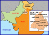
The final boundary, known as the Radcliffe award, allotted some sixty-two percent of the area of undivided Punjab to India, with fifty-five percent of the population.15 The boundary ran from the border of Kashmir State south along the Ujh River, leaving one tehsil16 of Gurdaspur District to Pakistan and allotting the remainder to India. Where the Ujh met the Ravi River, the boundary followed the Ravi southwest, until it met the existing administrative line dividing Amritsar District from Lahore District. Radcliffe was careful to specify that the relevant administrative boundaries, not the course of the Ujh or the Ravi, constituted the new international boundary. The boundary then ran through Lahore District, along tehsil and village boundaries, leaving the district’s easternmost corner in India. When the Radcliffe boundary met the Ferozepore District line, it turned to follow the River Sutlej along the administrative boundary between Ferozepore and Montgomery Districts. The Radcliffe line ended where it met the border of Bahawalpur, a princely state whose ruler, like the Maharajah of Kashmir, had the choice of acceding to Pakistan or India.
The primary feature of this line was that it divided Amritsar, now in India, from Lahore, which went to Pakistan. By and large it followed major administrative divisions, although it did meander between villages in the Kasur region southeast of Lahore. The two most controversial elements of this line involved Gurdaspur and Ferozepore. Pakistani critics interpreted Radcliffe’s decision to grant most of Gurdaspur District to India as an attempt to provide India with a land link to Kashmir. As one element of the beginnings of the Kashmir conflict, this allegation remains controversial. It is worth noting that no all-weather road linked Kashmir and India in 1947; when the first Indo-Pakistani war began in late 1947, India airlifted troops and supplies into Kashmir rather than take an overland route. The other controversy was over Ferozepore’s allocation to India; this decision came as a surprise in the wake of early August leaks indicating that Radcliffe would allocate a section of Ferozepore to Pakistan.
In accordance with Mountbatten, Nehru, and Jinnah’s demands that he complete his work before August 15, Radcliffe submitted his award on August 12. By this time, Mountbatten had changed his mind (for reasons discussed below) and asked Radcliffe to delay the award until after August 15. Radcliffe refused, but Mountbatten had his way, choosing not to release the award until August 16, when he discussed it with the Indian and Pakistani leaders at a meeting in New Delhi. On August 17, the award was finally published.
Allegations of Bias
Throughout the difficult process of partition, accusations of official partiality towards one group or another were leveled on all sides, not only in the popular press but also by the leaders themselves. For example, Justice Munir of the Punjab Commission accused Radcliffe’s top aide, Christopher Beaumont, of pro-Hindus bias. Munir claimed that Beaumont intentionally misled Radcliffe in order to achieve a result favorable to India.17 Beaumont rejects these charges as ludicrous. The most contentious point was the Ferozepore border and the nearby headworks. On August 8, Mountbatten’s private secretary, George Abell, sent a letter with a preliminary description of the Punjab boundary to Evan Jenkins, the provincial governor. This draft showed the Ferozepore area and its headworks going to Pakistan. When the final award was released, Ferozepore was assigned to India. Infuriated Pakistanis were sure that Nehru and Mountbatten had pressured Radcliffe to change his line. After partition, each side leveled accusations in the vernacular press that their opponents had successfully bribed Radcliffe to take their part.18
Many were convinced that the Commissions were a sham and that Mountbatten himself had simply dictated the new divisions. In his final report as Viceroy, Mountbatten admitted, "I am afraid that there is still a large section of public opinion in this country which is firmly convinced that I will settle the matter finally."19 In 1992, Christopher Beaumont added his voice to the chorus of accusations against Mountbatten.20 This circumstantial evidence indicates that Mountbatten may well have influenced the final shape of the boundary award.
I argue, however, that these allegations and angry resentments miss the point. On the contrary, it would not be surprising if Mountbatten offered Radcliffe advice, nor if Radcliffe took it. As one historian has noted, "Radcliffe was a barrister following a brief"—and Mountbatten was his client.21 Those who object to Mountbatten’s interference are buying in to the myth that the partition was a rational, objective process.
The Problem of "Other Factors"
One of the most difficult questions facing the Commissions was the respective significance to assign to various "other factors." In his awards, Radcliffe himself noted that "differences of opinion as to the significance of the term ‘other factors’ and as to the weight and value to be attached to these factors, made it impossible to arrive at any agreed line."22 The Congress argued that the unreliability of the 1941 census figures meant that "other factors" must be given greater weight in the Punjab; the Muslim League maintained that the census figures were valid and thus "other factors" could be all but ignored. Over the years, observers have speculated on various factors that may have motivated Radcliffe, including communal bias, pressure from Mountbatten, economic considerations, prevailing administrative borders, defense needs, and existing infrastructure.
Mountbatten
Years later, Mountbatten offered this curious appraisal of Radcliffe’s reasoning: "I’ll tell you something ghastly. The reasons behind his award weren’t very deep-seated at all. I am quite certain they were based on some rule of thumb about the proportion of population."23 Given the fact the Mountbatten’s government gave Radcliffe the mandate to focus on religious demographics, it seems odd that the former Viceroy thought it "ghastly" that Radcliffe had not come up with "deeper" reasons for drawing his lines. Mountbatten’s sentiment may indicate an awareness among British officials that the categories they themselves had set up were inadequate for the job at hand.
Even by Mountbatten’s standards, this statement about Radcliffe’s "rule of thumb" is rather peculiar. Perhaps by the time Mountbatten gave this interview, in the early 1970s, he had developed reservations about the partition process. Until his death, Mountbatten staunchly defended his actions in 1947, making it unlikely that he would openly question himself.24 However, Mountbatten had a great capacity for remembering history differently than other observers, invariably along lines most flattering to himself. Given Hodson’s statement that it was the viceroy himself who brought up the notion of "balance," one wonders whether Mountbatten subconsciously transferred responsibility for his own idea onto Radcliffe’s shoulders, before criticizing it. This speculation may seem rather convoluted, but Mountbatten was a notably twisty individual. A colleague famously told him, "Dickie, you’re so crooked that if you swallowed a nail you’d **** a corkscrew!" Mountbatten’s biographer records that this was "a remark which Mountbatten remembered and repeated, though characteristically changing the recipient of the insult.25
Some observers felt Radcliffe gave too much weight to economic considerations, neglecting his mandate to determine the "contiguous majority areas" of religious groups. For example, the Chittagong Hill Tracts in Bengal were awarded to Pakistan despite the fact that the Muslim population amounted to only three per cent. When Nehru complained on August 16, Mountbatten explained Radcliffe’s decision, emphasizing "the economic ties that bound Chit-tagong District and the Hill Tracts together."26 Radcliffe apparently thought these economic necessities more important than the overwhelmingly non-Muslim population.
Whenever possible, Radcliffe used existing administrative borders. The commission’s terms of reference directed it to draw its lines within the two provinces of Bengal and Punjab, so the existing provincial administrative boundaries were not an option. Within provinces, however, Radcliffe seems to have preferred existing lines, using district, tehsil, thana,27 and even village boundaries. His textual description of the boundary relies very little on "natural" landmarks like crest or rivers. In the Punjab award, Radcliffe repeatedly notes that although nearby rivers present apparently logical natural boundaries, the new boundary must run along the existing district or tehsil borders.28
Mountbatten recalled later that he had counseled Radcliffe "not to take defence considerations under judgment in making the award."29 In a memo dated May 11, 1946, Field Marshall Sir Claude Auchinleck, Commander-in-Chief of the Indian Armed Forces, discussed the repercussions of Partition for imperial and Indo-Pakistani defense. He concluded that without a united India, the British military position in South Asia would be irreparably damaged. Furthermore, although he considered the possibility of Indo-Pakistani conflict, he saw no way to define a defensible frontier.30 Radcliffe himself seems to have consistently operated on the assumption that India and Pakistan would have good relations after independence. Other decision-makers—and those impacted by the divisions—took this view as well. Radcliffe repeatedly expressed hope that India and Pakistan could work together to solve some of the most difficult infrastructure problems created by his boundary award. Mountbatten himself seemed optimistic that inclusion in the Commonwealth would keep India and Pakistan on mutually friendly terms, emphasizing that Dominion Status meant membership in a community of cooperative nations.
The Role of Infrastructure
Although the prominence of "other factors" in Radcliffe’s thinking remains unclear, his awards demonstrate the importance of infrastructure considerations. In both the Punjab and Bengal awards, Radcliffe discusses canals, headworks, roads, railways, and ports before turning to population factors. In the Punjab awards, he explicitly states that "there are factors such as the disruption of railway communications and water systems that ought in this instance to displace the primary claim of contiguous majorities."31 In the Bengal award, he demonstrates a similar concern with maintaining "railway communications and river systems," as well as preserving the relationship of the Nadia and Kulti river systems with the port of Calcutta.32
The irrigation systems and other infrastructure of Punjab and Bengal had been built under a single administration. They were never intended to be divided. No partition line Radcliffe could have concocted would have allowed Pakistan and India to operate their infrastructure separately, without cross-border interference. In the few weeks he had, Radcliffe seems to have tried to minimize infrastructure disruptions, but he was well aware that his proposal was flawed. In his attempt to draw the boundary near the Suleimanke headworks in Punjab, for example, he emphasized that his intention was to award this equipment to Pakistan and acknowledged that the reality of the terrain might necessitate that "the boundary shall be adjusted accordingly."33 Several months later, the Suleimanke headworks were "reallocated" in a clash between Indian and Pakistani soldiers.34 In an optimistic moment, Radcliffe expressed the hope that "a solution may be found by agreement between the two States for some joint control of what has hitherto been a valuable common service."35 Events soon proved this optimism unfounded.
The Boundary Announcement Delayed
Radcliffe had prepared his decision by August 12, as the various parties, including Mountbatten, had insisted. As the transfer of power approached, however, Mountbatten chose to delay the boundary announcement until after the independence ceremonies. In public statements, Mountbatten insisted that he simply wished to avoid spoiling the joyous celebration of independence by announcing news that would undoubtedly distress all parties. However, in private government communications and in the minutes of the Staff Meeting at which the decision was taken, it becomes clear that Mountbatten’s primary motivation was avoiding the appearance of British responsibility for the disorder that inevitably would follow the announcement.36
It is difficult to see how these concerns, either for Indian or Pakistani national joy or for the evasion of British national responsibility, could outweigh the potential benefit of making administrative, military, and constabulary arrangements before the actual transfer of power took place. Governor Jenkins of the Punjab had begged Mountbatten repeatedly for advance notice of the award. On July 30, Jenkins told the Viceroy that "even a few hours would be better than none."37 As it was, in some border regions whose destiny was uncertain, both Indian and Pakistani flags were raised. In some cases Pakistani officials set to work in territories that later became Indian. As August 15 drew closer, many administrators joined the last-minute flow of refugees themselves, disrupting administrative access across India by leaving their posts empty. In short, the Punjab found itself in administrative chaos, ill prepared to deal with the impact of partition.
When Mountbatten released the award to the Indian and Pakistani leaders on August 16, both sides objected furiously to various aspects of the boundary. In the end, they agreed to issue the decision as it stood, with no public statement of their disappointment. When the award was finally announced, on 17 August, the border forces in place were inadequate to stop the communal massacres. Violence was particularly severe along the new border areas, although there was serious bloodshed in Delhi as well. The first Indo-Pakistani war broke out in late 1947; both Pakistan and India sent troops into Kashmir, where they remain today. Subsequent wars in 1965 and 1971 made it clear that Radcliffe’s boundaries were not neat lines but raw and restless divisions.
REPERCUSSIONS OF PARTITION
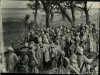
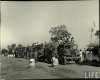
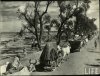
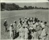
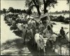
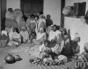
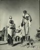
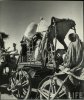
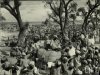
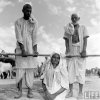
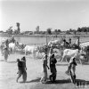
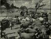
The partition resulted in extreme violence and one of the largest migrations in history. Partition deaths throughout India and Pakistan numbered between 500,000 and one million, while some ten to twelve million migrants moved across the new borders in Punjab and Bengal.38 In addition, tens of thousands of girls and women were raped and/or abducted.39 Violence was the most dramatic repercussion of partition, but the boundary award contributed to other disruptions: long-term border tensions, infrastructure problems, and the lasting conflict over Kashmir.
First, the high casualties and tremendous population dislocation that burdened both India and Pakistan during and after partition proved awkward responsibilities for fledgling states. In Pakistan, the position of mohajirs, or migrants from India, remains a dangerous political problem.
Second, the boundaries that Radcliffe defined turned out to be restless divisions, and in both the 1965 and 1971 wars India and Pakistan battled over their Punjabi border.
Third, the Radcliffe Line also cut through the Punjab’s well-developed infrastructure systems, disrupting road, telephone, and telegraph communications, but most importantly, interfering with the region’s vital irrigation system. In a rare success story, the 1960 Indus Waters Treaty largely resolved Punjab’s water-related problems. However, those original water problems were related to the final and most serious issue plaguing current Indo-Pakistani relations: Kashmir.
In 1947, Kashmir was a princely state, whose ruler was entitled to choose for himself between India and Pakistan; Radcliffe had no direct responsibility for the Kashmir question. However, there are a number of interesting links between Kashmir and the Radcliffe award. Those links include the fact that the water feeding the Punjabi irrigation system originates in Kashmiri rivers, as well as allegations that Radcliffe awarded India certain areas of northern Punjab as a strategic corridor to Kashmir. One of the most intriguing connections between the Radcliffe award and the Kashmir problem involves not the substance of the award but the possibility that Mountbatten, the last Viceroy of British India, who delayed the announcement of the Radcliffe award until two days after independence, may have done so in an effort to coerce the Maharajah of Kashmir into acceding to India rather than Pakistan.40 The truth of these allegations remains uncertain; what is clear is that the political successes that the Radcliffe Commission enabled have been less lasting than its failures.
Although estimates of partition casualties remain controversial, it is clear that great suffering, on a scale rarely seen in human history, accompanied the partition. Violence, and the memory of violence, is therefore one of partition’s legacies to the South Asian region. It is not 1947’s only legacy, of course—that year also brought independence and great pride to many Indians and Pakistanis—but partition’s scars remain in the minds, if no longer on the bodies, of many South Asians. It is not only the actual survivors of partition who exhibit this damage; their descendents are also marked. Pakistani bitterness against India and Indians and Indian bitterness against Pakistan and Pakistani are facts of life in South Asia. Many other Indians and Pakistanis long for peace, feeling that the people across the border are their kinfolk, but government propaganda and certain streams of public discourse, including those generated by media and educational institutions, reinforce cross-border resentments.
LESSONS OF PARTITION
In addition to providing a detailed analysis of the Radcliffe Boundary Commission’s composition and work, this project seeks to identify specific ways in which the 1947 partition failed. My hope is that describing these failures may assist policymakers considering partition in other regions to define the practical steps necessary to implement workable divisions.
In addition to the irregular boundary-making process detailed above, the larger South Asian partition was flawed in several major ways. The most significant error, for which all parties must share responsibility, was misguided reliance on a best-case result, combined with consistent refusal even to acknowledge the possibility of a worst-case outcome. Mountbatten and the rest of the interim Government of India ignored repeated warnings from Sir Evan Jenkins, the highly respected Governor of the Punjab, that the division would result in large-scale violence.
In addition, the architects of partition refused to provide a sufficiently prolonged timetable to allow for
1) the necessary geographic surveys and other information gathering, for
2) boundary demarcation (the process of fixing boundary markers on the ground), for
3) public announcement of the new line, and for
4) transfer of populations, if necessary.
If they had provided more time for government institutions and local communities to absorb and adapt to the implications of the Radcliffe award, the level of violence might have been lower—and the authorities’ abilities to impose law and order higher.
In their rush to achieve their own political goals, British India’s most powerful parties decided not to complete territorial partition before final political separation. This decision left Indian and Pakistani citizens in the peculiar predicament of not knowing which country they were in on August 15 or 16. Additionally, Mountbatten’s delay in announcing the Radcliffe Line meant effectively that India and Pakistan had no boundaries for the first two days of their existence. Even if the award had been announced a few days earlier, provincial and local officials would not have had enough time—particularly in the demanding circumstances they faced—to make the necessary administrative arrangements.
Finally, they did not define cooperative procedures for resource sharing or, failing that, clear and complete division of linked infrastructure systems. The result was severe infrastructure disruptions, with consequences not only for communications and transportation, but also for the food supply of millions of people. Future partitions must include these elements in order to avoid the failures that so tragically limited the effectiveness of the South Asian partition. The daunting nature of this task, particularly the intricate problem of linked infrastructures, makes it clear that partition must be a last resort. Further work on the conditions under which partition is likely to be more or less successful is also required to understand the full nature of this diplomatic option.
CONCLUSIONS
The story of the creation of the Indo-Pakistani boundary remains a neglected, yet crucial, element of partition history. Further research is required to place the boundary question within the larger historical context of partition and of British and South Asian politics in the 1940s. In addition, the precise nature of links between the boundary commission’s work and the violence of partition remains to be explored. Instead of resolving tension by clearly separating religious groups, the Boundary Commission may actually have contributed to the upheaval, albeit without malicious intent. The surge in violence that began shortly before the Radcliffe award was announced can be traced in part to rumors and uncertainty over where the Line would fall.41 A lengthier and more transparent boundary-making process might have averted this situation. The lack of a methodologically sound boundary-making process must be counted prominently among the failures of the South Asian division, and present-day policy-makers should consider this and the other flaws identified above when appraising the value of partition as a tool for conflict resolution.
Finally, this project challenges the notion that partition can be appraised in absolute terms, as a flawed approach that merely aggravates violence.42 In reality, it often both limits and exacerbates tension; one of the paradoxes of the 1947 partition is that it stimulated new violence even as it resolved political conflict on some levels. I hope this analysis will contribute to a more nuanced and practical understanding of the ways that partition can contribute to containing violence, the steps and conditions required for effective divisions, and the limits of this particular tool for peace.
http://www.unc.edu/depts/diplomat/archives_roll/2002_01-03/chester_partition/chester_partition.html
by Lucy Chester
The author, a visiting fellow at the Center for International Security and Cooperation at Stanford University, is a doctoral candidate in history at Yale University. Drawing from her dissertation, she considers here the background to timely questions associated with the Kashmir dispute. She raises the policy question of partition as a tool for crisis management or resolution, and she provides useful historical evidence for scholars wishing to draw contemporary lessons.—Ed.
Introduction
The 1947 partition of South Asia has had lasting repercussions not only for the region, but also for the larger international community. Border tensions between India and Pakistan have taken on a new magnitude since both countries carried out nuclear tests in May 1998. Surprisingly, historians have paid little attention to the creation of the Indo-Pakistani boundary, a key element of the 1947 division.1 This article analyzes the problematic procedure and format of the body responsible for delineating that boundary through the province of Punjab, the Radcliffe Boundary Commission.2 It is part of a larger project that will examine links between the boundary-making process and the repercussions of partition, particularly mass violence. The commission takes its name from its chairman, Sir Cyril Radcliffe. In the end, his boundary-making effort was a failure in terms of boundary-making, but a striking success in terms of providing political cover to all sides. The British seized the opportunity to withdraw from their onerous Indian responsibilities as quickly as possible; the Indian National Congress, the avowedly secular but primarily Hindu party headed by Jawaharlal Nehru and Sardar Patel, took control of India, as it had desired for so long. The Muslim League, which claimed to represent South Asia’s Muslims and was led by Muhammad Ali Jinnah, won Pakistan, the sovereign Muslim state for which it had campaigned.
Jinnah, Patel, and Nehru
Although the British had, in 1946, considered leaving India piecemeal, transferring power to individual provences as they withdrew, they concluded that such an approach was impractical. without defining the entity or entities that would come into power, they concluded that such an approach was impractical. It would not be possible to hand over power without making it clear what international entity would take on that power; in order to define a new international entity, a new boundary was necessary. From a certain perspective, however, a rigorously and properly delineated boundary was not necessary to accomplish these political ends—any boundary line would do. Due to this fact and to a myriad of political pressures, the Radcliffe Commission failed to draw a geopolitically sound line delineated and demarcated in accordance with accepted international procedure. The Punjab's population distribution was such that there was no line that could neatly divide Hindus, Muslims, and Sikhs. Radcliffe's line was far from perfect, but it is important to note that alternative borders would not necessarily have provided a significant improvement. There is, in contrast, a great deal to be said about flaws in the boundary-making procedure—and why those flaws existed.
Significance
This territorial division is significant on multiple levels. As an episode in imperial history, it marked the beginning of a global trend towards decolonization. For South Asian history, it meant independence for India and Pakistan. Unfortunately, it also inaugurated Indo-Pakistani tension. Conflict between Hindus and Muslims had existed on the subcontinent, to a greater or lesser degree, for many centuries, but the partition brought that conflict to the international level—and exacerbated it. The results include three wars, in 1948, 1965, and 1971, as well as the Kargil conflict of 1999. The problem of Indo-Pakistani tension took on greater urgency when both India and Pakistan tested their nuclear weapons in May 1998, and current events in South Asia demonstrate the need for continued attention to and greater understanding of this vital region.
How did this division intensify the very conflict it was intended to resolve? Part of the answer lies in the drawing of the boundary. My primary goal is to clarify and analyze the boundary-making process, but having identified specific flaws in this division, I hope to lay them out in terms that might be useful for decision-makers considering partition as a tool to resolve conflict in other regions of the world.
Methodology
Because this project focuses on a controversial episode, which reasonable historians describe differently according to their own national or political biases, my first research priority was balancing these varied perspectives. Accordingly, I gathered archival material and conducted interviews in England, Pakistan, and India. In all three countries, I focused on government documents, examining material relating to the work of the Radcliffe Commission and to the repercussions of the Radcliffe Line. I also examined private papers, mostly of British officials serving the raj, but also, where accessible, the papers of Indian and Pakistani leaders. Regrettably, Radcliffe destroyed all his papers before he left India—in keeping, his biographer claims, with a lifelong habit of discarding material he no longer needed.3 As a result, it may be impossible ever to clarify Radcliffe’s thinking completely. I have attempted to compensate through archival research and through interviews with Radcliffe’s stepson and executor, with his private secretary on the Boundary Commission, and with the last surviving Pakistani official associated with the Punjab Boundary Commission.4
This research explores the balance between structural influences and the role of individuals. My story centers on a small number of individuals: Radcliffe, the man who had responsibility for the boundary line; Mountbatten, the last viceroy of India; Nehru and Patel, leaders of the Indian National Congress; and Jinnah, head of the Muslim League. But my argument also has a great deal to do with the sweeping drives of British imperialism, Indian and Pakistani nationalism, and decolonization. My conclusions about the forces that shaped the Indo-Pakistani boundary would seem to support a structural approach, but the lessons of this particular division could be read another way. If at any point enough individuals had decided to take another path—for example, if Radcliffe had withdrawn his services once he reached India and was informed of the August 15 deadline—the outcome could have been dramatically different. Alternatively, if the key individuals had had different backgrounds—for example, if all the Indian leaders had not been lawyers, but rather businessmen or engineers—the outcome could again have been very different. The story of the Radcliffe Commission concerns individuals attempting to do what they saw as best, and as a result both bowing to and struggling against the pressures of larger structural forces.
Historical Context
The 1947 partition was shaped not only by decades of Indian nationalist pressure on the British Government and by the rise of civil unrest in the subcontinent after World War Two, but also by Britain’s precarious economic position in the aftermath of the war. After nearly two centuries as an economic asset, British India had become a liability at a time when Britain could least afford it. In addition, American pressure to decolonize the subcontinent influenced both international and British domestic opinion against the raj. British India became a political and symbolic liability as well as an economic problem. These factors, combined with domestic political considerations for the newly elected Labour Party, meant that ridding itself of its responsibilities in India suddenly became a priority to His Majesty’s Government (HMG).
However, Indian independence had not always been such an urgent goal for the British Government. The first half of the twentieth century saw a series of small steps towards self-government in South Asia. Traditional imperialist historiography holds that these ventures marked carefully incremented progress, part of the process of training Indians to govern themselves. Other interpretations, including but not confined to South Asian nationalist schools, argue that these steps were actually sops intended to keep nationalists satisfied enough to prevent a more serious threat to British rule.5 This view holds that HMG had no intention of letting go its "jewel in the crown"—until it had no choice.
Many historians, imperialist and nationalist alike, trace the roots of partition to the Morley-Minto reforms of 1909. These changes increased Indian participation in their own governance, anticipating an eventual move to self-rule.6 By creating separate electorates for different religious groups, however, these reforms also "embed[ded] deeply in Indian life the idea that its society consisted of groups set apart from each other. . . . The result was the flowering of a new communal rhetoric, and ultimately, of the Pakistan movement."7 Politicians found religious rhetoric useful for rallying support, with dangerous results. The elections of 1937 and 1945-46, in which both Congress and the Muslim League rhetoric played on communal themes, provided further evidence of a lack of political cooperation at the highest levels.
With the onset of the Second World War, the Government of India found itself in a difficult position. HMG declared war on India’s behalf, without even a pretense of consulting Indian leaders. Indian politicians and public opinion were outraged. The prospect of civil unrest loomed.8 In 1942, with the Allies in urgent need of a reliable Indian base, Churchill dispatched Sir Stafford Cripps to India at the head of a Cabinet delegation charged with exploring the possibility of self-government after the war. Cripps offered an implicit promise that if India fought in World War II it would be granted freedom; Congress rejected this offer with Gandhi’s memorable phrase that it was a "post-dated cheque on a bank that was failing."9 In the aftermath of Cripps’s failed mission, Gandhi launched the "Quit India" movement, which the British repressed violently. Most Indians subsided into more or less supportive attitudes.10
With the end of the war, Indian leaders and people alike expected to be repaid, with independence, for their wartime backing. In Britain, the Conservatives were voted out and the Labour Party took power, under Clement Attlee. Meanwhile, the India Office was losing patience with its viceroy, Lord Wavell. Relations between the India Office and Wavell had been steadily worsening throughout 1946. Wavell, a career military man whose stolid exterior concealed a bent for writing poetry, had been viceroy of India since 1943. Left with the difficult job of guiding India through treacherous post-war waters, he sent increasingly blunt warnings to London that their Indian policies were misguided and inadequate to the challenges ahead. Lord Pethick-Lawrence, Britain’s Secretary of State for India, resented these warnings and paid less attention to them as time went on. In particular, Wavell’s outline of potential partition boundaries, the first serious discussion of the issue, received little attention. However, Wavell’s "Breakdown Plan," calling for a withdrawal of all British presence in South Asia, alarmed HMG. Attlee sent another cabinet mission to India in hopes of negotiating a less drastic outcome.11 The resulting proposal, known as the "ABC Plan," called for a loose federation to consist of three groups of provinces, each of which had the option to "opt out" of the federation. This proposal met a curious reception. It was first accepted, then rejected, by Congress; the Muslim League initially announced that it would cooperate, but in the aftermath of the Congress decision it renounced constitutional methods and declared "Direct Action" Day on August 16, 1946. "Direct Action Day" became the "Great Calcutta Killing," and the next thirteen months saw rioting and violence across North India.12
By the beginning of 1947, Pethick-Lawrence and Attlee had lost all confidence in Wavell, regarding him as "frankly defeatist." In February 1947, they asked him to resign, appointing Lord Louis Mountbatten, a career naval officer and cousin to the king, in his place. Although Mountbatten was given a June 1948 deadline by which to disentangle Britain from India, he concluded shortly after his arrival in India that a rapprochement between the various parties was impossible. Within a few months he decided to move the decolonization deadline up, to August 15, 1947.
Boundary Commission Format and Procedure
It was not until the summer of 1947 that British and South Asian leaders began serious discussions about the format and procedure of a boundary commission. All in all, however, the central parties agreed on all aspects of the Boundary Commission arrangements with surprisingly little wrangling. There would be two commissions, one for Bengal, in northeast India, and one for Punjab, in the northwest. The same man, Sir Cyril Radcliffe, would chair both commissions. Radcliffe was widely respected for his intellectual abilities, but he had never been to India. Paradoxically, this fact made him a more attractive candidate, on the theory that ignorance of India would equal impartiality. Each commission would consist of four South Asian judges, two selected by Congress and two by the League. In the end, this two-versus-two format and the judges’ strong political biases produced deadlock, leaving Radcliffe the responsibility to make all the most difficult decisions himself. The commission’s terms of reference directed it to "demarcate the boundaries of the two parts of the Punjab on the basis of ascertaining the contiguous majority areas of Muslims and non-Muslims. In doing so, it will also take into account other factors."13 These terms, with their vague reference to "other factors," allowed the Chairman enormous leeway. However, after the final boundary decision, known as the "Radcliffe Award," was announced, all sides complained that Radcliffe had not taken the right "other factors" into account.
This structure limited the commission’s effectiveness, but the most serious flaw was the extremely tight timetable that the British Government, Congress, and League imposed on the entire partition effort. Radcliffe arrived in India on July 8 and met with Mountbatten and the nationalist leaders soon thereafter. It was at this meeting that Radcliffe learned, apparently for the first time, that the boundary must be completed by August 15. He protested, but Mountbatten, Nehru, and Jinnah stood firm. Despite warnings that the time restriction could wreck the end result, they wanted the line finished by August 15.
Radcliffe’s efforts were further hampered by the fact that he was almost completely ignorant of the information and procedures necessary to draw a boundary, procedures that were well established by 1947.14 Moreover, he lacked any advisors versed in even the basics of boundary-making, and only his private secretary, Christopher Beaumont, was familiar with the realities of administration and everyday life in the Punjab. Radcliffe’s South Asian colleagues, all legal experts like himself, were as ignorant as their Chairman of boundary-making requirements.
However, Radcliffe was not as unbiased, nor as ignorant, as the Indian leaders assumed. On the contrary, his wartime experience as director-general of the British Ministry of Information, along with his sound Establishment background, left him intimately familiar with the goals and interests of His Majesty’s Government. There is no evidence that Radcliffe was biased against Hindus, Muslims, or Sikhs, but he was certainly biased in favor of preserving British interests. As far as its undeclared political ends were concerned, then, the Radcliffe Commission was well arranged. Unfortunately, the forces that shaped the commission to fulfill political needs also prevented it from following well-established boundary-making procedures.
The commission’s membership, composed entirely of legal experts, hampered its boundary-making effort but added a valuable veneer of justice and legitimacy to what was, in reality, a chaotic jumble of events. Its composition of equal numbers of Congress and League nominees paved the way to deadlock but created an appearance of political balance. The presence of these political nominees came at the expense of the use of the necessary geographical experts, but satisfied the demands of Congress, League, and of course the British Government to have their own men on the commission. The absence of outside participants—for example, from the United Nations—also satisfied the British Government’s urgent desire to save face by avoiding the appearance that it required outside help to govern—or stop governing—its own empire. The Commission’s extremely tight timetable made it impossible to gather the survey and other information vital to a well-informed decision, but speedily provided all parties with the international boundary that was a prerequisite for the transfer of power.
Analysis of the Boundary Decision
The Facts of the Award
The final boundary, known as the Radcliffe award, allotted some sixty-two percent of the area of undivided Punjab to India, with fifty-five percent of the population.15 The boundary ran from the border of Kashmir State south along the Ujh River, leaving one tehsil16 of Gurdaspur District to Pakistan and allotting the remainder to India. Where the Ujh met the Ravi River, the boundary followed the Ravi southwest, until it met the existing administrative line dividing Amritsar District from Lahore District. Radcliffe was careful to specify that the relevant administrative boundaries, not the course of the Ujh or the Ravi, constituted the new international boundary. The boundary then ran through Lahore District, along tehsil and village boundaries, leaving the district’s easternmost corner in India. When the Radcliffe boundary met the Ferozepore District line, it turned to follow the River Sutlej along the administrative boundary between Ferozepore and Montgomery Districts. The Radcliffe line ended where it met the border of Bahawalpur, a princely state whose ruler, like the Maharajah of Kashmir, had the choice of acceding to Pakistan or India.
The primary feature of this line was that it divided Amritsar, now in India, from Lahore, which went to Pakistan. By and large it followed major administrative divisions, although it did meander between villages in the Kasur region southeast of Lahore. The two most controversial elements of this line involved Gurdaspur and Ferozepore. Pakistani critics interpreted Radcliffe’s decision to grant most of Gurdaspur District to India as an attempt to provide India with a land link to Kashmir. As one element of the beginnings of the Kashmir conflict, this allegation remains controversial. It is worth noting that no all-weather road linked Kashmir and India in 1947; when the first Indo-Pakistani war began in late 1947, India airlifted troops and supplies into Kashmir rather than take an overland route. The other controversy was over Ferozepore’s allocation to India; this decision came as a surprise in the wake of early August leaks indicating that Radcliffe would allocate a section of Ferozepore to Pakistan.
In accordance with Mountbatten, Nehru, and Jinnah’s demands that he complete his work before August 15, Radcliffe submitted his award on August 12. By this time, Mountbatten had changed his mind (for reasons discussed below) and asked Radcliffe to delay the award until after August 15. Radcliffe refused, but Mountbatten had his way, choosing not to release the award until August 16, when he discussed it with the Indian and Pakistani leaders at a meeting in New Delhi. On August 17, the award was finally published.
Allegations of Bias
Throughout the difficult process of partition, accusations of official partiality towards one group or another were leveled on all sides, not only in the popular press but also by the leaders themselves. For example, Justice Munir of the Punjab Commission accused Radcliffe’s top aide, Christopher Beaumont, of pro-Hindus bias. Munir claimed that Beaumont intentionally misled Radcliffe in order to achieve a result favorable to India.17 Beaumont rejects these charges as ludicrous. The most contentious point was the Ferozepore border and the nearby headworks. On August 8, Mountbatten’s private secretary, George Abell, sent a letter with a preliminary description of the Punjab boundary to Evan Jenkins, the provincial governor. This draft showed the Ferozepore area and its headworks going to Pakistan. When the final award was released, Ferozepore was assigned to India. Infuriated Pakistanis were sure that Nehru and Mountbatten had pressured Radcliffe to change his line. After partition, each side leveled accusations in the vernacular press that their opponents had successfully bribed Radcliffe to take their part.18
Many were convinced that the Commissions were a sham and that Mountbatten himself had simply dictated the new divisions. In his final report as Viceroy, Mountbatten admitted, "I am afraid that there is still a large section of public opinion in this country which is firmly convinced that I will settle the matter finally."19 In 1992, Christopher Beaumont added his voice to the chorus of accusations against Mountbatten.20 This circumstantial evidence indicates that Mountbatten may well have influenced the final shape of the boundary award.
I argue, however, that these allegations and angry resentments miss the point. On the contrary, it would not be surprising if Mountbatten offered Radcliffe advice, nor if Radcliffe took it. As one historian has noted, "Radcliffe was a barrister following a brief"—and Mountbatten was his client.21 Those who object to Mountbatten’s interference are buying in to the myth that the partition was a rational, objective process.
The Problem of "Other Factors"
One of the most difficult questions facing the Commissions was the respective significance to assign to various "other factors." In his awards, Radcliffe himself noted that "differences of opinion as to the significance of the term ‘other factors’ and as to the weight and value to be attached to these factors, made it impossible to arrive at any agreed line."22 The Congress argued that the unreliability of the 1941 census figures meant that "other factors" must be given greater weight in the Punjab; the Muslim League maintained that the census figures were valid and thus "other factors" could be all but ignored. Over the years, observers have speculated on various factors that may have motivated Radcliffe, including communal bias, pressure from Mountbatten, economic considerations, prevailing administrative borders, defense needs, and existing infrastructure.
Mountbatten
Years later, Mountbatten offered this curious appraisal of Radcliffe’s reasoning: "I’ll tell you something ghastly. The reasons behind his award weren’t very deep-seated at all. I am quite certain they were based on some rule of thumb about the proportion of population."23 Given the fact the Mountbatten’s government gave Radcliffe the mandate to focus on religious demographics, it seems odd that the former Viceroy thought it "ghastly" that Radcliffe had not come up with "deeper" reasons for drawing his lines. Mountbatten’s sentiment may indicate an awareness among British officials that the categories they themselves had set up were inadequate for the job at hand.
Even by Mountbatten’s standards, this statement about Radcliffe’s "rule of thumb" is rather peculiar. Perhaps by the time Mountbatten gave this interview, in the early 1970s, he had developed reservations about the partition process. Until his death, Mountbatten staunchly defended his actions in 1947, making it unlikely that he would openly question himself.24 However, Mountbatten had a great capacity for remembering history differently than other observers, invariably along lines most flattering to himself. Given Hodson’s statement that it was the viceroy himself who brought up the notion of "balance," one wonders whether Mountbatten subconsciously transferred responsibility for his own idea onto Radcliffe’s shoulders, before criticizing it. This speculation may seem rather convoluted, but Mountbatten was a notably twisty individual. A colleague famously told him, "Dickie, you’re so crooked that if you swallowed a nail you’d **** a corkscrew!" Mountbatten’s biographer records that this was "a remark which Mountbatten remembered and repeated, though characteristically changing the recipient of the insult.25
Some observers felt Radcliffe gave too much weight to economic considerations, neglecting his mandate to determine the "contiguous majority areas" of religious groups. For example, the Chittagong Hill Tracts in Bengal were awarded to Pakistan despite the fact that the Muslim population amounted to only three per cent. When Nehru complained on August 16, Mountbatten explained Radcliffe’s decision, emphasizing "the economic ties that bound Chit-tagong District and the Hill Tracts together."26 Radcliffe apparently thought these economic necessities more important than the overwhelmingly non-Muslim population.
Whenever possible, Radcliffe used existing administrative borders. The commission’s terms of reference directed it to draw its lines within the two provinces of Bengal and Punjab, so the existing provincial administrative boundaries were not an option. Within provinces, however, Radcliffe seems to have preferred existing lines, using district, tehsil, thana,27 and even village boundaries. His textual description of the boundary relies very little on "natural" landmarks like crest or rivers. In the Punjab award, Radcliffe repeatedly notes that although nearby rivers present apparently logical natural boundaries, the new boundary must run along the existing district or tehsil borders.28
Mountbatten recalled later that he had counseled Radcliffe "not to take defence considerations under judgment in making the award."29 In a memo dated May 11, 1946, Field Marshall Sir Claude Auchinleck, Commander-in-Chief of the Indian Armed Forces, discussed the repercussions of Partition for imperial and Indo-Pakistani defense. He concluded that without a united India, the British military position in South Asia would be irreparably damaged. Furthermore, although he considered the possibility of Indo-Pakistani conflict, he saw no way to define a defensible frontier.30 Radcliffe himself seems to have consistently operated on the assumption that India and Pakistan would have good relations after independence. Other decision-makers—and those impacted by the divisions—took this view as well. Radcliffe repeatedly expressed hope that India and Pakistan could work together to solve some of the most difficult infrastructure problems created by his boundary award. Mountbatten himself seemed optimistic that inclusion in the Commonwealth would keep India and Pakistan on mutually friendly terms, emphasizing that Dominion Status meant membership in a community of cooperative nations.
The Role of Infrastructure
Although the prominence of "other factors" in Radcliffe’s thinking remains unclear, his awards demonstrate the importance of infrastructure considerations. In both the Punjab and Bengal awards, Radcliffe discusses canals, headworks, roads, railways, and ports before turning to population factors. In the Punjab awards, he explicitly states that "there are factors such as the disruption of railway communications and water systems that ought in this instance to displace the primary claim of contiguous majorities."31 In the Bengal award, he demonstrates a similar concern with maintaining "railway communications and river systems," as well as preserving the relationship of the Nadia and Kulti river systems with the port of Calcutta.32
The irrigation systems and other infrastructure of Punjab and Bengal had been built under a single administration. They were never intended to be divided. No partition line Radcliffe could have concocted would have allowed Pakistan and India to operate their infrastructure separately, without cross-border interference. In the few weeks he had, Radcliffe seems to have tried to minimize infrastructure disruptions, but he was well aware that his proposal was flawed. In his attempt to draw the boundary near the Suleimanke headworks in Punjab, for example, he emphasized that his intention was to award this equipment to Pakistan and acknowledged that the reality of the terrain might necessitate that "the boundary shall be adjusted accordingly."33 Several months later, the Suleimanke headworks were "reallocated" in a clash between Indian and Pakistani soldiers.34 In an optimistic moment, Radcliffe expressed the hope that "a solution may be found by agreement between the two States for some joint control of what has hitherto been a valuable common service."35 Events soon proved this optimism unfounded.
The Boundary Announcement Delayed
Radcliffe had prepared his decision by August 12, as the various parties, including Mountbatten, had insisted. As the transfer of power approached, however, Mountbatten chose to delay the boundary announcement until after the independence ceremonies. In public statements, Mountbatten insisted that he simply wished to avoid spoiling the joyous celebration of independence by announcing news that would undoubtedly distress all parties. However, in private government communications and in the minutes of the Staff Meeting at which the decision was taken, it becomes clear that Mountbatten’s primary motivation was avoiding the appearance of British responsibility for the disorder that inevitably would follow the announcement.36
It is difficult to see how these concerns, either for Indian or Pakistani national joy or for the evasion of British national responsibility, could outweigh the potential benefit of making administrative, military, and constabulary arrangements before the actual transfer of power took place. Governor Jenkins of the Punjab had begged Mountbatten repeatedly for advance notice of the award. On July 30, Jenkins told the Viceroy that "even a few hours would be better than none."37 As it was, in some border regions whose destiny was uncertain, both Indian and Pakistani flags were raised. In some cases Pakistani officials set to work in territories that later became Indian. As August 15 drew closer, many administrators joined the last-minute flow of refugees themselves, disrupting administrative access across India by leaving their posts empty. In short, the Punjab found itself in administrative chaos, ill prepared to deal with the impact of partition.
When Mountbatten released the award to the Indian and Pakistani leaders on August 16, both sides objected furiously to various aspects of the boundary. In the end, they agreed to issue the decision as it stood, with no public statement of their disappointment. When the award was finally announced, on 17 August, the border forces in place were inadequate to stop the communal massacres. Violence was particularly severe along the new border areas, although there was serious bloodshed in Delhi as well. The first Indo-Pakistani war broke out in late 1947; both Pakistan and India sent troops into Kashmir, where they remain today. Subsequent wars in 1965 and 1971 made it clear that Radcliffe’s boundaries were not neat lines but raw and restless divisions.
REPERCUSSIONS OF PARTITION
The partition resulted in extreme violence and one of the largest migrations in history. Partition deaths throughout India and Pakistan numbered between 500,000 and one million, while some ten to twelve million migrants moved across the new borders in Punjab and Bengal.38 In addition, tens of thousands of girls and women were raped and/or abducted.39 Violence was the most dramatic repercussion of partition, but the boundary award contributed to other disruptions: long-term border tensions, infrastructure problems, and the lasting conflict over Kashmir.
First, the high casualties and tremendous population dislocation that burdened both India and Pakistan during and after partition proved awkward responsibilities for fledgling states. In Pakistan, the position of mohajirs, or migrants from India, remains a dangerous political problem.
Second, the boundaries that Radcliffe defined turned out to be restless divisions, and in both the 1965 and 1971 wars India and Pakistan battled over their Punjabi border.
Third, the Radcliffe Line also cut through the Punjab’s well-developed infrastructure systems, disrupting road, telephone, and telegraph communications, but most importantly, interfering with the region’s vital irrigation system. In a rare success story, the 1960 Indus Waters Treaty largely resolved Punjab’s water-related problems. However, those original water problems were related to the final and most serious issue plaguing current Indo-Pakistani relations: Kashmir.
In 1947, Kashmir was a princely state, whose ruler was entitled to choose for himself between India and Pakistan; Radcliffe had no direct responsibility for the Kashmir question. However, there are a number of interesting links between Kashmir and the Radcliffe award. Those links include the fact that the water feeding the Punjabi irrigation system originates in Kashmiri rivers, as well as allegations that Radcliffe awarded India certain areas of northern Punjab as a strategic corridor to Kashmir. One of the most intriguing connections between the Radcliffe award and the Kashmir problem involves not the substance of the award but the possibility that Mountbatten, the last Viceroy of British India, who delayed the announcement of the Radcliffe award until two days after independence, may have done so in an effort to coerce the Maharajah of Kashmir into acceding to India rather than Pakistan.40 The truth of these allegations remains uncertain; what is clear is that the political successes that the Radcliffe Commission enabled have been less lasting than its failures.
Although estimates of partition casualties remain controversial, it is clear that great suffering, on a scale rarely seen in human history, accompanied the partition. Violence, and the memory of violence, is therefore one of partition’s legacies to the South Asian region. It is not 1947’s only legacy, of course—that year also brought independence and great pride to many Indians and Pakistanis—but partition’s scars remain in the minds, if no longer on the bodies, of many South Asians. It is not only the actual survivors of partition who exhibit this damage; their descendents are also marked. Pakistani bitterness against India and Indians and Indian bitterness against Pakistan and Pakistani are facts of life in South Asia. Many other Indians and Pakistanis long for peace, feeling that the people across the border are their kinfolk, but government propaganda and certain streams of public discourse, including those generated by media and educational institutions, reinforce cross-border resentments.
LESSONS OF PARTITION
In addition to providing a detailed analysis of the Radcliffe Boundary Commission’s composition and work, this project seeks to identify specific ways in which the 1947 partition failed. My hope is that describing these failures may assist policymakers considering partition in other regions to define the practical steps necessary to implement workable divisions.
In addition to the irregular boundary-making process detailed above, the larger South Asian partition was flawed in several major ways. The most significant error, for which all parties must share responsibility, was misguided reliance on a best-case result, combined with consistent refusal even to acknowledge the possibility of a worst-case outcome. Mountbatten and the rest of the interim Government of India ignored repeated warnings from Sir Evan Jenkins, the highly respected Governor of the Punjab, that the division would result in large-scale violence.
In addition, the architects of partition refused to provide a sufficiently prolonged timetable to allow for
1) the necessary geographic surveys and other information gathering, for
2) boundary demarcation (the process of fixing boundary markers on the ground), for
3) public announcement of the new line, and for
4) transfer of populations, if necessary.
If they had provided more time for government institutions and local communities to absorb and adapt to the implications of the Radcliffe award, the level of violence might have been lower—and the authorities’ abilities to impose law and order higher.
In their rush to achieve their own political goals, British India’s most powerful parties decided not to complete territorial partition before final political separation. This decision left Indian and Pakistani citizens in the peculiar predicament of not knowing which country they were in on August 15 or 16. Additionally, Mountbatten’s delay in announcing the Radcliffe Line meant effectively that India and Pakistan had no boundaries for the first two days of their existence. Even if the award had been announced a few days earlier, provincial and local officials would not have had enough time—particularly in the demanding circumstances they faced—to make the necessary administrative arrangements.
Finally, they did not define cooperative procedures for resource sharing or, failing that, clear and complete division of linked infrastructure systems. The result was severe infrastructure disruptions, with consequences not only for communications and transportation, but also for the food supply of millions of people. Future partitions must include these elements in order to avoid the failures that so tragically limited the effectiveness of the South Asian partition. The daunting nature of this task, particularly the intricate problem of linked infrastructures, makes it clear that partition must be a last resort. Further work on the conditions under which partition is likely to be more or less successful is also required to understand the full nature of this diplomatic option.
CONCLUSIONS
The story of the creation of the Indo-Pakistani boundary remains a neglected, yet crucial, element of partition history. Further research is required to place the boundary question within the larger historical context of partition and of British and South Asian politics in the 1940s. In addition, the precise nature of links between the boundary commission’s work and the violence of partition remains to be explored. Instead of resolving tension by clearly separating religious groups, the Boundary Commission may actually have contributed to the upheaval, albeit without malicious intent. The surge in violence that began shortly before the Radcliffe award was announced can be traced in part to rumors and uncertainty over where the Line would fall.41 A lengthier and more transparent boundary-making process might have averted this situation. The lack of a methodologically sound boundary-making process must be counted prominently among the failures of the South Asian division, and present-day policy-makers should consider this and the other flaws identified above when appraising the value of partition as a tool for conflict resolution.
Finally, this project challenges the notion that partition can be appraised in absolute terms, as a flawed approach that merely aggravates violence.42 In reality, it often both limits and exacerbates tension; one of the paradoxes of the 1947 partition is that it stimulated new violence even as it resolved political conflict on some levels. I hope this analysis will contribute to a more nuanced and practical understanding of the ways that partition can contribute to containing violence, the steps and conditions required for effective divisions, and the limits of this particular tool for peace.
http://www.unc.edu/depts/diplomat/archives_roll/2002_01-03/chester_partition/chester_partition.html